Drones and Sugar Beet: Case Study
Today, we will consider a case study of a practical application of unmanned aerial drones on sugar beet fields. The fields are based in Ukraine and owned by a huge landfarming corporation.
Drones and Sugar Beet: How We Had Started
We came to do aerial photography on the field with sugar beet. The objectives of the aerial photography of the field with beets have a direct link with a desire to improve the economic benefits of growing crops.
In fact, our Customer was a large agricultural holding. It has a huge land bank and plants not only sugar beet but also other crops.
The Customer demonstrated his interest in the drones, as satellite images were a bit pricey, even for their rubber budget. Therefore, we agreed to our aerial survey methods. Owner of a Drone Company and Drone Pilot
Immediately it should be noted that the management of the Customer is not typical agricultural industry workers, who do everything the old-fashioned style. It was clear that they were willing to take risks for the sake of winning the subsequent. In other words, a good harvest. So that our cooperation can be attributed to the category of such risks.
Benefits of Drone Application for Fields
Looking ahead, I note that in their opinion, these risks have paid off and they got what they wanted. Although this benefit is indirect, because the value was not derived from data from drones pictures, and by improving the quality of work of employees of the Customer.
I will explain in detail: the majority of Customer’s employees knew that either the drones or any other unmanned vehicles will fly over the fields and monitor the growth of plants.
Therefore, all employees tried to work more efficiently and did not want to get punished for bad attitude to work. That, accordingly, has yielded good results in terms of the productivity of their fields.
In brief, the use of unmanned aerial vehicles improved the discipline of the Customer’s employees.
Main Goals of Application of Drones on Sugar Beet Field
But, from the point of view of the efficiency of the application of geoinformation technologies, I can say that the work was carried out efficiently. Although the interpretation of the data obtained during aerial drones has been ineffective. And now I will explain why.
Let’s start with a specific purpose – why did we take this aerial photography?
To be able to analyze the level of beet seedlings after seeding. To evaluate the quality of seeds, the need for top dressing, but most importantly – to take effective decisions and act.
That is, to save the crop, where the worst of vegetation indices were obtained. It is also important to understand that these actions are not made globally. In other words, not the entire field. But locally and point, in those places where we saw a negative trend.
Somewhere in a month, our goals were scaled. And we also do aerial photos to identify the place of condensation of undesirable vegetation. I.e. weeds that struggle was better and more effective with them.
Again, we had to deal with the localization of specific point of foci of such undesirable vegetation.
Also, to kill weeds many companies use manned aircraft and the complex of aviation-chemical works. Although it should be borne in mind that these chemicals work negatively affect the yield of major crops.
With goals completed.
Practical Showcase of Applying Drones in a Field
So what have we had in practice?
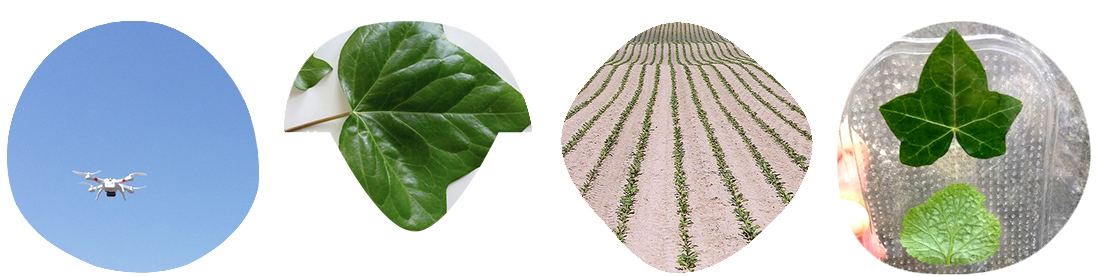
First, we flew about ten fields (total area of 70 square kilometres). We took height – 100 meters, with a resolution of 1.5 cm/pixel. Beet shoots are visible. We can clearly see them.
But immediately faced with the problem of huge amounts of data to quickly process and analyze that just unreal.
And whether it is necessary?
Problems with Performance on Drone Flights
Plus there were problems with the performance of the work of our team. We flew 12 flights (three flight days of four flights each day). We used our UAV “Peter be-E”. And we managed to take only a tenth of the required material.
In the calculations, we assumed that planting beets lasted about two weeks. In fact, we had to carry out an aerial survey for the same time.
Finally, we came to the conclusion that the time is very expensive to fly with full coverage and overlap for stitching. Therefore, we made a representative survey, the overlapping on the direct. And, therefore, the data, which we obtained from our 10% shot areas, is relevant for the entire crop area. Hence, we interpreted it.
Of course, first of all, it affected the representativeness. Because we simply define a coating which we have to fly around to meet deadlines. In addition, we got a serious puzzle with the problem of image processing with high extension.
Calculate the amount for beet bushes in each frame, you can use the program to analyze images. For example, Definiens. Of course, the cost of using this software is very expensive. More than 20,000 euros for a single license.
But you can start with a trial version. And as a result – to decide whether it is necessary at all.
Although more interesting for us was not only counting the number of bushes in each frame image, but also the construction of the bushes density function per unit area.
The order of frames we have arranged according to the log file on a digital map of the terrain.